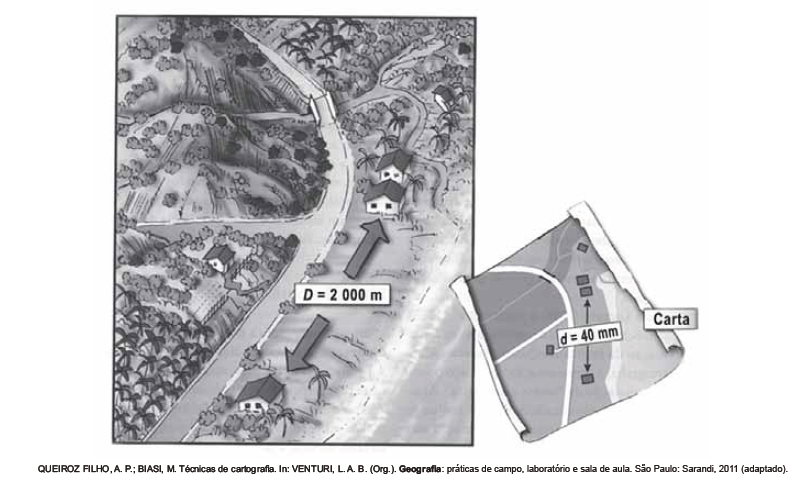
As figuras representam a distância real (D) entre duas residências e a distância proporcional (d) em uma representação cartográfica, as quais permitem estabelecer relações espaciais entre o mapa e o terreno. Para a ilustração apresentada, a escala numérica correta é:
Questões relacionadas
- Biologia | 13.2 Primeira Lei de Mendel
(PUC-RJ) O albinismo é uma condição recessiva caracterizada pela total ausência de pigmentação (melanina) na pele, nos olhos e no cabelo. Na fi gura, um casal (A e B) planeja ter um fi lho (C).

Sabendo que B (mãe) é albina e A (pai) tem irmãos albinos, a probabilidade de A ser portador do alelo para o albinismo e de C ser albino é, respectivamente:
- Geografia - Fundamental | 3.04 Pirâmides Etárias
Observe, a seguir, duas pirâmides etárias da Itália, em dois períodos distintos:
A análise e comparação das duas pirâmides permite concluir que:
- Física
O ar atmosférico pode ser utilizado para armazenar o excedente de energia gerada no sistema elétrico, diminuindo seu desperdício, por meio do seguinte processo: água e gás carbônico são inicialmente removidos do ar atmosférico e a massa de ar restante é resfriada até – 198ºC Presente na proporção de 78% dessa massa de ar, o nitrogênio gasoso é liquefeito, ocupando um volume 700 vezes menor. A energia excedente do sistema elétrico é utilizada nesse processo, sendo parcialmente recuperada quando o nitrogênio líquido, exposto à temperatura ambiente, entra em ebulição e se expande, fazendo girar turbinas que convertem energia mecânica em energia elétrica.No processo descrito, o excedente de energia elétrica é armazenado pela:
- Física | 4.4 Lentes e Visão
(UESB) Com relação à Óptica e às anomalias da visão, é correto afirmar:
I. A superfície refletora de um farol de automóvel é um espelho côncavo.
II. Pessoas míopes possuem o globo ocular longo e, para corrigir esse defeito, elas devem usar lentes convergentes.
III. Um olho hipermetrope tem o ponto próximo a 50,0 cm. Esse olho, para enxergar objetos a 25,0 cm, deve utilizar lentes de contato de 2,0 dioptrias.
IV. Uma aplicação de reflexão total da luz se dá nas fibras ópticas.
Nessas condições, a alternativa em que todas essas afirmativas estão corretas é a
- Biologia
(FUVEST) Na história evolutiva dos metazoários, o processo digestivo: