(ITA) New York City closed several blocks of Broadway in 2009 to create a pedestrian plaza around Times Square – a much-publicized experiment that in February became permanent policy, even though it did not improve traffic flow as much as hoped. The Big Apple has also dabbled in shorter-term but larger-scale street closures, barring cars on a stretch of streets leading from the Brooklyn Bridge to Central Park on a series of summer Saturdays in 2008 and 2009. And on June 7, New York City Mayor Michael Bloomberg announced a somewhat less sexy but nonetheless significant change in the city’s infrastructure, instituting dedicated bus-only lanes on Manhattan’s East Side to speed transit up and down the island.
Each of the measures instituted in the U.S.’s largest city turns over what had been primarily automotive-ruled space to pedestrians, cyclists or mass transit. In doing so the city follows a trend that has caught on in Europe and Latin America – in some cases long ago – but that has been slow to take root in the U.S. If New York and other American cities such as Portland, Ore., prove to be on the vanguard domestically, the changes there could portend a shift in the way urbanites in the U.S. use their streets in the years and decades to come.
“It clearly is a trend,” says Lester Brown, president of the nonprofit Earth Policy Institute in Washington, D.C. “I think there are many cities that are ahead on this. Several years ago I was in Stockholm, and already there were many blocks where cars were banned.”
Brown points to Enrique Peñalosa, who served as mayor of Bogotá, Colombia, from 1998 to 2001, as a pioneer in the kinds of changes now reaching the U.S. “He’s the one who really redefined things when he took office,” Brown says. The city’s bus rapid transit (BRT) network, TransMilenio, is in many ways more like a subway system, with its own median-protected lanes and station platforms for loading and unloading passengers. Similar BRT systems have sprung up in places such as Mexico City and Ahmedabad, India, giving over lanes of the road exclusively to bus traffic.
“Thinking about why these kinds of reclamation make sense, I always talk about the spatial efficiency of walking, biking and buses,” says Paul White, executive director of the New York City nonprofit advocacy group Transportation Alternatives. “When you think about what cities are, they are defined by their density – by definition the space between buildings is limited.” The car, he adds, is the lowest density mode of transportation; that is, a person traveling by car takes up far more space than someone on a bicycle or on a bus. “In many respects cities are all the same in terms of supply and demand,” White says. “There’s always more demand for street use than there are streets.”
Looking forward, White sees a more malleable future for the way streets are used. With retractable barriers, city planners can create socalled time-flexible streets, which might be open to vehicle traffic during part of the day and pedestrian-only at other times. “You’re accommodating peak use – that could be peak deliveries in the morning and peak pedestrian use during lunchtime,” he says. “That’s something I think you’ll see more of, and something we're pushing for.”
By John Matson June 15, 2010,http://www.scientificamerican.com/article.cfm?id=car-free-streets,Acesso em 19/06/2010 (adapted)
As expressões em negrito nas orações a seguir, extraídas do primeiro parágrafo,
I. …even though it did not improve traffic flow as much as hoped.
II ... but nonetheless significant change in the city’s infrastructure, ... podem ser substituídas, respectivamente, por
Questões relacionadas
- Inglês - Fundamental | Não Possui Tópico Definido
Enunciado:
Jacob, Emily and Malia are predicting lives in 15 years. Fill in the blanks with the verbs in the near future in the box.
1. Jacob ________________ two kids.
2. Malia ________________ famous.
3. Malia ________________ children.
4. Jacob ________________ in the same place.
5. Emily ________________ married.
- Matemática | 10. Estatística
Nos últimos anos, o aumento da população, aliado ao crescente consumo de água, tem gerado inúmeras preocupações, incluindo o uso desta na produção de alimentos. O gráfico mostra a quantidade de litros de água necessária para a produção de 1 kg de alguns alimentos.
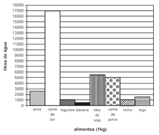
Com base no gráfico, para a produção de 100 kg de milho, 100 kg de trigo, 100 kg de arroz, 100 kg de carne de porco e 600 kg de carne de boi, a quantidade média necessária de água, por quilograma de alimento produzido, é aproximadamente igual a:
- História - Fundamental | Não Possui Tópico Definido
Para resolver a questão, leia o texto a seguir.
Tem um bicho na parede
Nas paredes e tetos de cavernas pré-históricas, em várias partes do mundo, mamutes, veados, bisões e outros animais selvagens fogem de seus caçadores. Com as pinturas rupestres, como são chamadas, o homem pré-histórico representava o cotidiano.
Ele desenhava figuras humanas, as emocionantes caçadas, os tipos de plantas que rodeavam a "casa", os rituais, e muitas outras cenas do dia-a-dia. Como a agricultura ainda não tinha sido desenvolvida, eles deixaram nas paredes as pegadas da principal atividade que garantia a sobrevivência: a caça.
De 25000 a 8000 a.C. (antes de Cristo), no período conhecido como Paleolítico, ou Idade da Pedra Lascada (mais primitiva, anterior ao uso de instrumentos), os antepassados do homem atual utilizavam carvão para contornar os desenhos. Coloriam o interior com o pó de blocos de terra esfarelada utilizando pincéis grosseiros de peles e folhas, que tingiam os desenhos em tons avermelhados.
Já no Período Neolítico (por volta de 5.000 a 3.000 a.C.), os artistas das cavernas tiravam leite de pedra! Isto é, tinta! Raspavam pedras coloridas e misturavam o pó desses minérios com resina de árvores e cera de abelha. A mistura virava uma espécie de tinta, que fixou as cores nas pedras por milênios.
O vermelho e o amarelo, por exemplo, eram obtidos do minério de ferro. Os artistas pintavam com os dedos, com pincéis feitos de pêlo de animais e espátulas de madeira, e utilizavam os relevos das paredes como parte da cena. Assim, uma elevação da pedra poderia ser o enorme dorso de um mamute furioso, e dois buraquinhos podiam ser os olhos de um cavalo apavorado.
Eram espertos, esses artistas antigos. Não tinham muitos recursos, mas fizeram seus trabalhos tão bem feitos que até hoje os bichos parecem estar correndo em cavernas na Europa, na África, nas Américas, preservados contra a ação do tempo.
Muito mais tarde, o homem iria pintar sobre papel, tela, cerâmica, madeira, seda, e até ovos. Mas essas primeiras pinturas são especiais. São a memória dos primeiros homens que e tornaram artistas, mesmo sem saber que aquilo já era arte...
Disponível:http://www.canalkids.com.br/arte/pintura/bicho.htm. Acesso em: 20 nov. 2011.
As pinturas rupestres podem ser definidas como
- Língua Portuguesa | 1.04 Inferência, Dedução ou Conclusão
(ENEM 2009 2ª APLICAÇÃO) Em entrevista à revista Info Exame, o pesquisador Don Tapscott, autor que estuda o fenômeno da Geração Net, quando perguntado acerca do aumento do desnível entre quem tem acesso à tecnologia e quem não tem, respondeu que “O divisor digital é um problema, mas está melhorando. Nos países mais desenvolvidos, como os do G20 (grupo que inclui o Brasil), o acesso a ferramentas digitais não é terrivelmente caro para a maioria da população. Obviamente, há famílias que têm dificuldades até para se alimentar. Assim, a experiência de bibliotecas ou centros comunitários com acesso livre à Internet é importante”.
INFO Exame. Para quem vive de tecnologia. São Paulo: Ed. Abril, n.° 274, dez. 2008, p. 53.(fragmento).
O acesso livre à Internet está relacionado ao acesso ao conhecimento produzido pela sociedade. Considerando o exposto pelo autor, conclui-se que:
- Língua Espanhola | 1. Interpretação de Textos
La evolución del hombre
[1] La evolución, el proceso de cambio a lo largo del
tiempo, es el hilo que conecta a la enorme diversidad del
mundo vivo. Una inmensa cantidad de evidencias indica que
[4] la Tierra ha tenido una larga historia y que todos los
organismos vivos — incluido el ser humano — surgieron en
el curso de esa historia, a partir de formas anteriores más
[7] primitivas. Esto implica que todas las especies descienden de
otras especies; en otras palabras, que los seres vivos
comparten antecesores comunes en el pasado distante. Así,
[10] los organismos son lo que son a raíz de su historia. Una serie
de evidencias llevaron a Darwin a concebir las ideas que
constituyen los pilares de la teoría evolutiva contemporánea.
[13] El concepto de gen propuesto por Mendel — pero
desconocido para Darwin — permitió comprender de qué
manera las variaciones podían originarse, preservarse y
[16] transmitirse de una generación a la siguiente.
Uno de los problemas más relevantes que discuten
los biólogos evolutivos en la actualidad es si los procesos
[19] microevolutivos pueden dar cuenta de los grandes cambios
macroevolutivos que revela el registro fósil. El origen de las
especies, uno de los grandes tipos de cambios
[22] macroevolutivos, es, en la actualidad, un tópico central para
los biólogos evolutivos.
Existe una pregunta que han venido formulando los
[25] especialistas desde finales del siglo XIX y que ha generado
interesantes controversias: ¿Cómo y cuándo comenzó la
historia de la evolución humana?
[28] Las características del comportamiento de un
organismo — su sensibilidad y sus patrones de respuesta a
estímulos particulares — son producto de la selección
[31] natural, tanto como lo es cualquiera de sus características
morfológicas, fisiológicas o bioquímicas. El estudio del
comportamiento involucra a científicos de las más diversas
[34] disciplinas.
Internet: <www.monografias.com> (con adaptaciones).
Con respecto a las ideas y estructuras lingüísticas del texto de arriba, juzgue lo siguiente ítem.
Se le debe a Mendel el concepto de gen que permitió entender en parte la evolución de las espécies.