
Os mapas representam distintos padrões de distribuição de processos socioespaciais. Nesse sentido, a menor incidência de disputas territoriais envolvendo povos indígenas se explica pela
Questões relacionadas
- Geografia | 5.1 População
Crescimento populacional mundial, 1700-2100
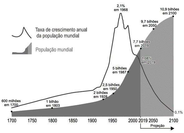
Disponível em: https://ourworldindata.org. Acesso em: 15 mar. 2022 (adaptado).
A análise do gráfico mostra que o período de
- Biologia | 12.8 Impactos Ambientais
O chorume é somente o líquido proveniente da decomposição da matéria orgânica, e os lixiviados, ou percolados, são a solução do chorume com a água, de origem superficial ou subterrânea. Sendo uma das principais fontes de poluição dos aterros sanitários, esses resíduos líquidos poluem as águas subterrâneas e o solo em que o lixo está depositado.
SÁ, L. F. de; JUCÁ, J. F. T.; SOBRINHO, M. A. Tratamento do lixiviado de aterro sanitário usando destilador solar.
Revista Ambiente & Água, v. 7, n. 1, 2012 (adaptado).
Para evitar o problema ambiental causado pelos resíduos citados no texto, é necessário que a gestão dos aterros sanitários
- Biologia | 14. Biotecnologia
(FCMMG) Salmão transgênico: animais geneticamente modificados para servir de alimento. O Salmão é o primeiro animal geneticamente modificado, a receber aprovação para servir de alimento no mundo: o salmão transgênico é uma realidade.
A criatura é uma produção da empresa AquaBounty. Ela colocou no salmão atlântico o DNA do salmão real, uma espécie gigante oriunda do Pacífico. A grande vantagem da espécie modificada é que ela cresce mais rapidamente que as outras: em um ano e meio atinge o tamanho típico dos três anos, que é o exigido pelo mercado. A nova espécie foi batizada como AquAdvantage. De acordo com o site da empresa, “somos uma pequena empresa com uma visão ousada. Queremos aumentar o número do melhor salmão do Atlântico. Um peixe que é nutritivo, delicioso, fresco e acessível”.

De acordo com os dados obtidos no texto, com o gráfico acima e com conhecimentos do assunto, NÃO podemos afirmar:
- Química | 1.6 Reações Inorgânicas
Os métodos empregados nas análises químicas são ferramentas importantes para se conhecer a composição dos diversos materiais presentes no meio ambiente. É comum, na análise de metais presentes em amostras ambientais, como água de rio ou de mar, a adição de um ácido mineral forte, normalmente o ácido nítrico (HNO3), com a finalidade de impedir a precipitação de compostos pouco solúveis desses metais ao longo do tempo.
Na ocorrência de precipitação, o resultado da análise pode ser subestimado, porque
- Geografia | B. Blocos Econômicos
 Disponível em: www.ipea.gov.br. Acesso em: 2 ago. 2013.
Na imagem, é ressaltado, em tom mais escuro, um grupo de países que na atualidade possuem características político-econômicas comuns, no sentido de